ASSESSING THE USEFULNESS OF UNMANNED AERIAL VEHICLE (UAV) FOR MONITORING SPATIAL PLAN: LEGAL AND USER PERSPECTIVE OF BOGOR REGENCY, INDONESIA
D. Maria, F. Hamdani, J. Pratomo, M. A. Pratama, G. S. A Bidari, S. Sherida
ABSTRACT
Monitoring is a critical process in managing the land use plan. However, the current approach to collecting data related to the land use has a shortcoming. First, field survey has limitation due to the high number of resources needed, i.e., people, funds, time. Second, the participatory approach has limitation due to the lack of involvement of the citizens. Unmanned Aerial Vehicle (UAV) has developed in recent years and it has been used in the various field, i.e., urban dynamics, asset monitoring, and so on. The usage of UAV to monitor urban changes has some advantages. First, it can cover a large area and used fewer resources compared with the field survey, in term of man hour, funds and time. Second, it may provide data with a high spatial resolution, which gives a broad possibility for analyzing urban features. This research aimed to assess the usefulness of UAV in monitoring the spatial plan of Bogor Regency, Indonesia. We developed indicator according to the legal and user perspective. Our research has shown that UAV may reduce the time and resources needed to monitor the spatial plan. However, the UAV has limitation since it is difficult to indicate the changes of the land use. Therefore, we suggest incorporating with the field survey
INTRODUCTION
Monitoring is a critical process in managing the spatial plan to ensure the compliance of the implementation process (Government of The Republic of Indonesia, 2007). In Indonesia, the monitoring process is divided into two categories, i.e., technical and specific monitoring (Government of The Republic of Indonesia, 2010). Technical monitoring consists of procedures, output, functions and benefits, and monitoring the achievement of standards of minimum service. Meanwhile, the specific monitoring includes data and information and technical study on specific problems.
Although monitoring process is crucial, current approach for data collection regarding spatial planning has limitations. First, field survey has limitation due to the high number of resources needed, i.e., people, funds, time. Second, the participatory approach has limitation due to the lack of involvement of the citizens. Another method, which is satellite based imagery also has limitation due to the impact of atmospheric conditions.
Unmanned Aerial Vehicle (UAV) has developed in recent years and it has been used in the various field, i.e., urban dynamics and asset monitoring. According to Kršák et al. (2016) UAV can be used to create new opportunities for documentation since it can measure the surface in detail, create orthophoto maps of the entire area and documents the difficult areas. Furthermore, the usage of UAV may cover a large area and used fewer resources compared with the field survey, in term of man hour, funds and time. UAV also may provide data with a high spatial resolution, which gives a broad possibility for various applications. Several studies have demonstrated the usage of UAV in an urban area. For instance, research from Salvo et al. (2014)has shown the usage of UAV for urban traffic analysis. Another research from Chen et al.(2016)developed a robust method for detecting building change from UAV image.
As the buffer city of Jakarta, Bogor Regency experienced a rapid urbanization, which led to an increased demand for land. Three factors have contributed to the land demands, i.e., population growth, structural change of the society and the economic developments (Fajarini, 2014). The impact of the rapid urbanization results in various forms of environmental degradation and the probability of violation in the spatial plan. Therefore, the local government is required to monitor the spatial plan regularly to prevent violations.
However, to monitor the implementation of spatial planning also have an issue. According to the Indonesian National Law Number 26/2007, the General Spatial Plan (RTRW) cannot be used for monitoring due to the lack detailed information (Purba, 2015). However, local governments rarely have the detailed spatial plan (RDTR), which may be used for monitoring the spatial plan. Often, they develop their procedure for this purpose. Therefore, it is necessary to indicate the requirement for monitoring from the legal and the user perspective.
Currently, the government of Bogor Regency used field survey for data acquisition. Although the size of Bogor Regency is large, which is 2.664 square kilometer, the number of people-in-charge for monitoring process is limited. The Government of Bogor Regency itself has set the target for monitoring land use for more than 1,000 land parcels per year. However, they can accommodate only 200 cases per year. This research aimed to assess the usefulness of UAV in monitoring the spatial plan of Bogor Regency, Indonesia according to the legal and user perspective.
DATA AND METHODS
To evaluate the usefulness of UAV in monitoring the spatial plan, we developed a set of indicators from the two sources. First, we conducted a literature review related to the legal requirement for monitoring the spatial plan. Second, we conducted an interview, to understand the needs and requirement of the user. According to these two sources, we developed a set of indicators. The qualitative evaluation was done by comparing the requirement of the monitoring process by the UAV’s feature. To elaborate the capability of UAV to fulfil the requirement, we conducted a literature review. By the end, we came out with a matrix that indicates the usefulness of the UAV for monitoring the spatial plan, particularly in Bogor Regency. The methods used in this research can be seen in figure 1.

Figure 1 – Research Methods
RESULTS AND DISCUSSIONS
Legal and Requirement
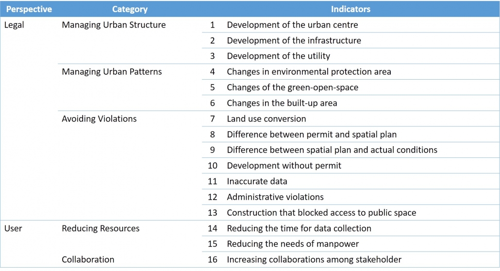
Two components are needed to be considered in monitoring the spatial plan, which is structure and pattern (Ministry of Public Works and Public Housing, 2015). Regarding monitoring the structure, some information needs to be collected. First, the change of urban center. Second, the change of the main infrastructure. Last, the change of utility. Meanwhile, monitoring pattern consists of three measurements. First, changes in the environmental protected area. Second, changes of open green space. Third, changes in the built-up area.
Acquisition of the data mentioned above is needed to indicate and prevent the violation of spatial plan. Several patterns can be classified as a violation of the spatial plan. First, conversion of the land use. Second, permit does not comply with the spatial plan. Third, a spatial plan does not matches with the actual conditions. Fourth, development without a license. Fifth, inaccuracy of data. Sixth, administrative violations during the licensing process. The last is construction of particular parcels affecting the accessibility of public facilities.
User Requirement
The monitoring process of the spatial plan in Bogor Regency is carried out by the Department of Spatial Planning and Land Management (DTRP). DTRP developed a Standard Operating Procedure (SOP) regarding the monitoring of the spatial plan. To conduct the monitoring process, DTRP also needs to cooperate with other working units, e.g. Board of Investment and Integrated Permit (BPTSP) and Civil Service Police (Satpol PP). DTRP Bogor serves as the first substation in monitoring activities as the issuance of the construction permit. Further intensive of monitoring activities are escorted by a unit of the Department of Building Management and Housing (DTBP) to minimise the infringement.
Regarding the procedure, DTRP started by conducting a field survey for every permitted that submitted to BPTSP. If violations are found, DTRP will issue a warning letter. If the offender does not settle the issue after the third warning, then the government has any right to dismantle or revoke the landowner permits. However, due to the limited resources, DTRP needs to create a priority, which developed according to the preliminary information obtained from district authorities, also information from the citizens. Regarding the time that consumed is depends on the area and the parcels that surveyed. For the parcels sized one hectare in the industrial area, it can be done by one day. Meanwhile, for the parcels in a densely populated residential, it required up to four days.
Development of Indicators
As discussed in introductions, we developed a set of indicators according to the legal and user perspective. From the legal point of view, we noticed that three activities need to monitors, which are monitoring urban structure, urban patterns and avoiding violations. Meanwhile, from the user perspective, we noticed that the user requires methods that may reduce the resources needed and increasing the collaboration among stakeholders. Therefore, we can summarise the indicators that can be used for evaluations, which can be seen in Table 1.
Table 1. Indicators of Evaluations
Evaluations
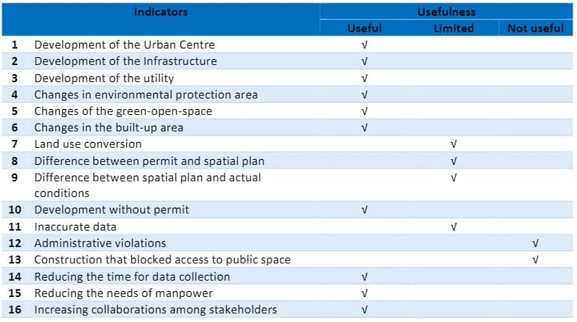
Regarding change monitoring of urban center, it requires data that periodically collected. The change of urban center might be observed by the change of the built-up area. For this requirement, the usage of UAV has an advantage due to its ability to be deployed in the particular area and various time. Several studies have shown the usefulness of UAV to acquire spatiotemporal data. For instance, Kim et al. (2016) employed multitemporal SAR data obtained from UAV for detecting durable and permanent changes in urban areas. Another study from Rosnell et al.(2011) tested the performance of image acquired from UAV in different seasons (winter, spring, summer, autumn) and conditions (sunny, cloudy, various solar elevations).
For the second and third indicator, which are infrastructure and utilities, the usage of UAV has advantages due to the high spatial resolutions. Current UAV camera may produce an image with 6 centimetres on the spatial resolution. The usage of very high resolution (VHR) may assist the detection of the small object. Regarding the application of UAV for monitoring infrastructure and utility has demonstrated in some research. For instance, Salvo et al. (2014)used the UAV for monitoring the traffic. Another research from Sankarasrinivasan et al. (2015)used the UAV to monitor the condition of the building structure.
Similar with the advantage of the UAV in monitoring urban center, infrastructure and utility, monitoring urban pattern also require methods that may acquire multi-temporal data with appropriate spatial resolutions. However, apart from these two requirements, monitoring urban pattern also needs a platform that can cover a large area. Current development of the UAV technology has created a platform with outstanding coverage and endurance, e.g., Orion Medium-Altitude Long Endurance UAV (Figure 2) have a flight radius of 4,000 miles and can fly for 120 hours.
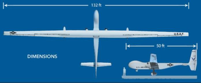
Figure 2. Orion UAV
Although the usage of UAV has demonstrated its usefulness in the first to the sixth indicator, apparently it has a limitation in monitoring land use conversion. Similar to different image acquisition methods, i.e., satellite imagery, not every land use class can easily detect from the image. For instance, office and the commercial area often have similar characteristics. Also, it is hard to distinguish between the public park and the vacant land. Hence, observing the land use from the ground is the most obvious approach. Although, some land use may be observed from the image, e.g., rice field and water body.
Since it is hard to monitor the land use from the UAV, it is also difficult to monitor the difference between a permit and spatial plan (indicator number eight) as well as the difference between spatial plan and actual conditions (indicator number nine). UAV also have limited use to solve the problems related to the accuracy of the land use data (indicator number 11). However, the UAV might be used to monitor development without a permit(indicator number ten), by comparing acquired image with the GIS data of building permit. We will indicate the violation if we find any changes in the particular area that do not have a building permit.
UAV have a limited use for detecting construction site that blocked access to public space. In this case, we need to define the relationship between construction sites, public facilities and the access to the public facilities. Furthermore, often the access itself is hard to define from the image. For instance, a vacant land has used as access to a public park. Hence, this case only can be detected by the local knowledge. Regarding the administrative process, UAV is of course not possible to detect this violations.
Regarding the user perception, the UAV is useful in term of reducing the time and manpower needed for data collections. Therefore, it can impact on the availability of up-to-date data that also can be used to increase the collaboration among stakeholders.
According to the above discussion, we summaries the usefulness of the UAV in Table 2.
Table 2. Summary of Evaluations
CONCLUSION
Our research has demonstrated the usage of UAV for monitoring the spatial plan. The combination of the legal and user perspective also gives a better understanding for assessing the usage of the UAV. However, UAV also has a limited usage in monitoring land use, which also similar with different image acquisition methods, i.e., satellite imagery. Since only particular land use that can be detected, incorporating with the field data is needed. In term of user perspective, UAV gives a better opportunity compared with the field survey in term of reducing the time and manpower needed.
ACKNOWLEDGEMENT
Funding for this research is obtained from Lokalaras Indonesia Institute. We also grateful by the support from the Government of Bogor Regency.
REFERENCES
- Chen, B., Chen, Z., Deng, L., Duan, Y., &Zhou, J. (2016). Building change detection with RGB-D map generated from UAV images. Neurocomputing, 1–15.
- Fajarini, R. (2014). The Dynamics of Land Use Change and the Spatial Plan of Bogor Regency (in bahasa). Bogor Agriculture Institute. Retrieved from http://repository.ipb.ac.id/handle/123456789/73120?show=full).
- Government of The Republic of Indonesia. National Law of Spatial Planning (in bahasa), Pub. L. No. 26/2007 (2007). Indonesia.
- Government of The Republic of Indonesia. Implementation of Spatial Planning (in bahasa), Pub. L. No. 15/2010 (2010). Indonesia.
- Kim, D. J., Hensley, S., Yun, S. H., & Neumann, M. (2016). Detection of Durable and Permanent Changes in Urban Areas Using Multitemporal Polarimetric UAVSAR Data. IEEE Geoscience and Remote Sensing Letters, 13(2), 267–271.
- Kršák, B., Blišťan, P., Pauliková, A., Puškárová, P., Kovanič, Ľ., Palková, J., & Zelizňaková, V. (2016). Use of low-cost UAV photogrammetry to analyse the accuracy of a digital elevation model in a case study. Measurement.
- Ministry of Public Works and Public Housing. (2015). Draft of Technical Documents on Monitoring and Evaluation of Spatial Planning (in bahasa)
- Purba, T. P. (2015). Audit of Spatial Plan in Indonesia: expectation and implementation (in bahasa). Retrieved from https://www.academia.edu/12785507/Audit_Tata_Ruang_di_Indonesia_Harapan_dan_Tindak_Lanjut
- Rosnell, T., Honkavaara, E., & Nurminen, K. (2011). On Geometric Processing of Multi-Temporal Image Data Collected By Light UAV Systems. ISPRS -International Archives of the Photogrammetry, Remote Sensing and Spatial Information Sciences, XXXVIII-1/, 63–68.
- Salvo, G., Caruso, L., & Scordo, A. (2014). Urban Traffic Analysis through an UAV. Procedia -Social and Behavioral Sciences, 111, 1083–1091.
- Sankarasrinivasan, S., Balasubramanian, E., Karthik, K., Chandrasekar, U., & Gupta, R. (2015). Health Monitoring of Civil Structures with Integrated UAV and Image Processing System. Procedia Computer Science, 54, 508–515